Updated: Winter Storm Warning, Cold Weather Advisory issued by NWS
From Staff Reports / UPDATED – Tuesday, 5 p.m.
The National Weather Service in Peachtree City has issued a Winter Storm Warning for Coweta County and much of North Georgia until 7 a.m. Wednesday.
NWS says heavy snow is expected with additional accumulations up to one inch.
Roads, and especially bridges and overpasses are slick and hazardous. Travel is not advised. The hazardous conditions will continue to impact the Tuesday evening and Wednesday morning commutes.
Also, a Cold Weather Advisory has been issued for Coweta County by the National Weather Service. The Advisory is in effect from 10 p.m. this evening until 9 a.m. Wednesday.
Wind Chills during the Cold Weather Advisory will range from 5 to 15 degrees..
For the latest local weather information, click HERE.
At 5 p.m. Tuesday, the temperature at Newnan-Coweta County Airport is 23 degrees with light snow and wind from the North at 5 mph, making the Wind Chill 17 degrees.
Below is the 24-hour forecast from NWS for Coweta County.
TUESDAY – Snow showers likely. Cloudy, with a high near 29. North wind around 5 mph. Chance of precipitation is 60%. Total daytime snow accumulation of around an inch possible.
TUESDAY NIGHT – A 30 percent chance of snow showers, mainly before 7 p.m. Mostly cloudy, with a low around 12. North wind around 5 mph. New snow accumulation of less than a half inch possible.
WEDNESDAY – Sunny, with a high near 37. North wind around 5 mph becoming calm in the afternoon.
•••••••••••••••••••••••••••••••••••••••••••••••••••••••••
From Staff Reports / UPDATED – Tuesday, 3:30 a.m.
The National Weather Service in Peachtree City has issued a Winter Weather Advisory for Coweta County and much of North Georgia from 10 a.m. today (Tuesday) until 7 a.m. Wednesday.
NWS says snow is expected with total accumulations up to one inch. Locally higher amounts remain possible. The latest forecast calls for less than a half inch here in Coweta County.
Plan on slippery road conditions. The hazardous conditions could impact the Tuesday evening and Wednesday morning commutes. Impacts on roads are expected even with low accumulations and shortly after precipitation begins.
Also, a pair of Cold Weather Advisories have been issued for Coweta County by the National Weather Service. The first is in effect overnight Monday until 9 a.m. Tuesday. The second is in effect from 10 p.m. Tuesday until 9 a.m. Wednesday.
Wind Chills during the Cold Weather Advisories could dip close to single digits, in the 10-15 degree range.
For the latest local weather information, click HERE.
At 3:35 a.m. Tuesday, the temperature at Newnan-Coweta County Airport is 21 degrees with wind from the North at 9 mph, making the Wind Chill 11 degrees.
Below is the 24-hour forecast from NWS for Coweta County.
TUESDAY – A 40 percent chance of snow, mainly after noon. Cloudy, with a high near 32. North wind around 5 mph, with gusts as high as 15 mph. New snow accumulation of less than a half inch possible.
TUESDAY NIGHT – A 20 percent chance of snow before 9 p.m. Mostly cloudy, with a low around 12. North wind around 5 mph, with gusts as high as 15 mph.
WEDNESDAY – Sunny, with a high near 37. North wind around 5 mph becoming southeast in the afternoon.
•••••••••••••••••••••••••••••••••••••••••••••••••••••••••
From Staff Reports / UPDATED – Monday, 6 a.m.
The National Weather Service in Peachtree City has issued a Winter Storm Watch for Coweta County and much of North Central Georgia to go into effect at 10 a.m. on Tuesday and end on Wednesday at 7 a.m.
NWS says periods of snow will be moderate to heavy at times. Total snow accumulations up to 2 inches is possible, though the NWS forecast below calls for about a half inch of snow in Coweta County. Plan on slippery road conditions. The hazardous conditions could impact the Tuesday evening and Wednesday morning commutes.
In addition, the NWS has issued a Cold Weather Advisory until 11 a.m. Monday. Very cold wind chills as low as 6 degrees are expected. For the lastest info, click NWS Coweta Weather.
Below is the 48-hour NWS Forecast for Coweta County.
MONDAY – Sunny, with a high near 31. North wind around 10 mph, with gusts as high as 20 mph.
MONDAY NIGHT – Mostly clear, with a low around 18. North wind 5 to 10 mph.
TUESDAY – A chance of flurries before 8 a.m., then a chance of snow after 11 a.m.. Mostly cloudy, with a high near 34. North wind 5 to 10 mph. Chance of precipitation is 50%. New snow accumulation of less than a half inch possible.
TUESDAY NIGHT – A 30 percent chance of snow showers before 1 a.m. Mostly cloudy, with a low around 13. North wind 5 to 10 mph, with gusts as high as 15 mph. .
WEDNESDAY – Sunny, with a high near 37. North wind around 5 mph becoming east in the afternoon.
•••••••••••••••••••••••••••••••••••••••••••••••••••••••••••
From Staff Reports / Sunday, 10:15 a.m.
The National Weather Service in Peachtree City has issued a Winter Storm Watch for Coweta County and much of North Central Georgia to go into effect at 10 a.m. on Tuesday and end on Wednesday at 7 a.m.
NWS says periods of snow that could be moderate to heavy at times is possible. Total snow accumulations between 1 and 3 inches. Plan on slippery road conditions. The hazardous conditions could impact the Tuesday evening and Wednesday morning commutes.
In addition, the NWS has issued a Cold Weather Advisory from 1 a.m. to 11 a.m. Monday. Very cold wind chills as low as 4 degrees are expected.
Below is the 72-hour forecast for Coweta County, per the National Weather Service.
SUNDAY – Mostly cloudy, with a temperature falling to around 37 by 5 p.m. Northwest wind around 15 mph, with gusts as high as 30 mph.
SUNDAY NIGHT – Partly cloudy, with a low around 16. Northwest wind 10 to 15 mph, with gusts as high as 25 mph.
MONDAY – Sunny, with a high near 31. North wind around 10 mph, with gusts as high as 20 mph.
MONDAY NIGHT – Mostly clear, with a low around 18. North wind around 5 mph.
TUESDAY – Snow showers likely after 1 p.m. Mostly cloudy, with a high near 33. North wind around 5 mph. Chance of precipitation is 60%.
TUESDAY NIGHT – A 50 percent chance of snow showers before 1 a.m. Mostly cloudy, with a low around 15.
WEDNESDAY – Sunny, with a high near 35.
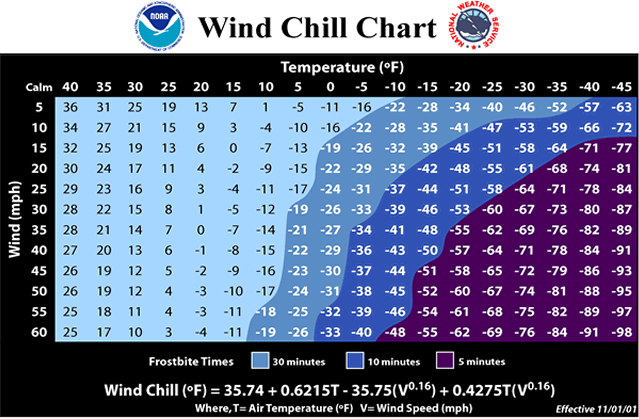
Wind Chill Chart from the National Weather Service.