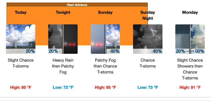
Heat Advisory in effect through Sunday for Coweta
From Staff Reports
A Heat Advisory has been issued by the National Weather Service in Peachtree City for much of Georgia, including Coweta County.
The advisory begins at 8 a.m. Saturday and runs through 8 p.m. Sunday night. Widespread heat index values at or exceeding 105 degrees are expected. Heat index values are what the temperature feels like to the human body when relative humidity is combined with the actual air temperature.
The Newnan forecast calls for a highs today and Sunday of 95 degrees with a heat index near 104.
Maximum heat index values will be highly dependent on sporadic thunderstorm development throughout the area in the morning and afternoon hours. These storms may cool off localized areas sooner than expected.
The National Weather Service offers some precautionary / preparedness actions during this advisory:
• Drink plenty of fluids, stay in an air-conditioned room, stay out of the sun, and check up on relatives and neighbors. Young children and pets should never be left unattended in vehicles under any circumstances.
• Take extra precautions if you work or spend time outside. When possible reschedule strenuous activities to early morning or evening. Know the signs and symptoms of heat exhaustion and heat stroke. Wear lightweight and loose fitting clothing when possible. To reduce risk during outdoor work, the Occupational Safety and Health Administration recommends scheduling frequent rest breaks in shaded or air conditioned environments. Anyone overcome by heat should be moved to a cool and shaded location. Heat stroke is an emergency! Call 9 1 1.
For updated weather information, click the following National Weather Service Newnan LINK.
Below is the detailed forecast for Newnan and Coweta County for the next several days.
SATURDAY – A slight chance of showers and thunderstorms before 2pm, then a slight chance of showers and thunderstorms after 3pm. Mostly sunny, with a high near 95. Heat index values as high as 104. South wind around 5 mph becoming northwest in the afternoon. Chance of precipitation is 20%.
SATURDAY NIGHT – A 20 percent chance of showers and thunderstorms before midnight. Some of the storms could produce heavy rainfall. Patchy fog after 2am. Otherwise, partly cloudy, with a low around 72. West wind around 5 mph becoming east in the evening.
SUNDAY – A 40 percent chance of showers and thunderstorms after 3pm. Patchy fog between 8am and 9am. Otherwise, mostly sunny, with a high near 95. Heat index values as high as 104. West wind 5 to 10 mph.
MONDAY – A slight chance of showers, then a chance of showers and thunderstorms after noon. Partly sunny, with a high near 91. West wind 5 to 10 mph. Chance of precipitation is 50%.
FOURTH OF JULY TUESDAY – A 50 percent chance of showers and thunderstorms, mainly after 3pm. Partly sunny, with a high near 92.