Weather: Cool start to week, warmer by Christmas Day

From Staff Reports
Winter officially arrives on Tuesday and with it will be cool, wet weather to get the season started. But, a warming trend moves in later in the week and by Christmas Day on Saturday, highs will be in the upper 60s.
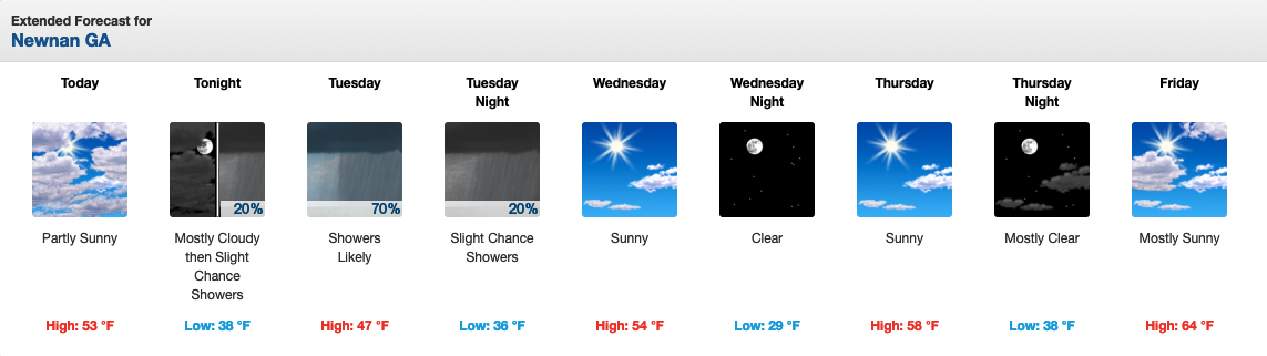
Coweta County can expect partly sunny skies today with a high temperature of only 53 degrees. Overnight, it becomes mostly cloudy with a slight rain chance and a low of 38.
On Tuesday as Winter begins around 11 a.m., it will be mostly cloudy with a high of 47 and a 70 percent rain chance after lunch. The rain chance drops to 20 percent later in the evening and the low will be 36.
The sunshine returns on Wednesday with a high near 54 and Northwest winds 5-10 mph, gusting to 15. A clear and cold Wednesday night sees the mercury fall below freezing to 29.
The warming trend kicks in on Thursday with sunny skies and a high of 58. Then Friday, the high pushes upward to 64 and finally on Christmas Day, the forecast calls for partly sunny skies and a high of 68.
Below is the extended forecast for Coweta. For up-to-date weather information, visit: NWS Newnan Page.
MONDAY – Partly sunny, with a high near 53. East wind 5 to 10 mph, with gusts as high as 15 mph.
MONDAY NIGHT – A 20 percent chance of showers after 4am. Mostly cloudy, with a low around 38. East wind around 5 mph.
TUESDAY – Showers likely, mainly after noon. Mostly cloudy, with a high near 47. Northeast wind around 5 mph. Chance of precipitation is 70%.
TUESDAY NIGHT – A 20 percent chance of showers before 1am. Mostly cloudy, with a low around 36. Northwest wind around 5 mph.
WEDNESDAY – Sunny, with a high near 54. Northwest wind 5 to 10 mph, with gusts as high as 15 mph.
THURSDAY – Sunny, with a high near 58.
CHRISTMAS EVE – Mostly sunny, with a high near 64.
CHRISTMAS DAY – Partly sunny, with a high near 68.
The Coweta County forecast for the week of Dec. 20-25 from the National Weather Service.


