Weather: High temperatures to be near 90 much of the work week

From Staff Reports
Hot and humid best describes the upcoming extended weather forecast for Coweta County, says the National Weather Service in Peachtree City.
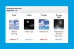
A chance of afternoon showers and thunderstorms are in the daily forecast through Saturday with high temperatures ranging from 83 today to 87 on Tuesday, 89 on Wednesday and 90 on Thursday and Friday.
Overnight lows will be in the mid-to-upper 60s.
The best chance of rain during the work week appears to be Wednesday as a 40 percent probability is in that day’s forecast. Otherwise, a 30 percent chance is listed for today, 20 percent Tuesday, 20 percent Thursday and 30 percent Friday.
Below is the extended forecast for Coweta from the National Weather Service in Peachtree City as of 6:55 a.m. on Monday, June 6, 2022. For up-to-date weather information, visit: NWS Newnan Page.
MONDAY – A 30 percent chance of showers and thunderstorms, mainly after 1pm. Mostly sunny, with a high near 83. Southeast wind 5 to 10 mph.
MONDAY NIGHT – A 30 percent chance of showers and thunderstorms, mainly before 7pm. Partly cloudy, with a low around 65. Southeast wind around 5 mph.
TUESDAY – A 20 percent chance of showers and thunderstorms after 2pm. Mostly sunny, with a high near 87. Southwest wind around 5 mph.
TUESDAY NIGHT – A 10 percent chance of showers and thunderstorms before 8pm. Partly cloudy, with a low around 68. Calm wind.
WEDNESDAY – A 40 percent chance of showers and thunderstorms, mainly after 2pm. Partly sunny, with a high near 89. Light west wind increasing to 5 to 10 mph in the morning.
THURSDAY – A 20 percent chance of showers and thunderstorms. Mostly sunny, with a high near 90.
FRIDAY – A 30 percent chance of showers and thunderstorms. Mostly sunny, with a high near 90.
SATURDAY – Showers likely and possibly a thunderstorm. Mostly cloudy, with a high near 81. Chance of precipitation is 60%.

The Coweta County extended weather forecast for the work week.